
Vancouver, BC – October 14, 2026 – Cariboo Rose Resources Ltd. (TSX-V: CRB) and BRS Resources Ltd. (TSX-V: BRS) announce results from a four-hole, 1,275-meter diamond drill program completed in July 2026 at the Cowtrail Project located in south-central British Columbia near the community of Williams Lake.
Cowtrail is a 4,717-hectare porphyry copper-gold project contiguous with the Woodjam and Redgold copper-gold porphyry projects owned by Vizsla Copper Corp. (TSX-V: VCU). It is situated in Upper Triassic rocks belonging to the Quesnel Terrane. These rocks host a number of economic copper-gold deposits including the Mount Polley, Afton and Copper Mountain Mines.
The broader Stikine Terrane of northwestern British Columbia hosts major porphyry copper-gold systems including Red Chris. This reference is provided as broader provincial geological context and is not intended to imply that Cowtrail is directly analogous to Red Chris.
Results of the 2026 drilling confirms the continuation of porphyry copper-gold mineralization drilled in 2023 and 2025 which remains open along strike and to depth. In hole CT26-28 mineralization continues to the bottom of hole with last sample grading 0.21 % copper and 0.11 g/t gold (0.32 % Cu Eq).
Hole CT26-28 is the first deep test of the Cowtrail project. Drill casing for this hole was left in place to allow it to be reentered and deepened.
Significant 2026 Drill Results
| Hole id | From | To | Interval | Copper | Gold | Copper Equivalent |
| (m) | (m) | (m) | (%) | (g/t) | % CuEq, | |
| CT26-26A | 133.0 | 172.0 | 39.0 | 0.03 | 0.17 | 0.20 |
| CT26-28 | 338.0 | 558.9 *EOH | 220.9 | 0.19 | 0.11 | 0.30 |
| Incl | 395.0 | 558.9 *EOH | 163.9 | 0.22 | 0.13 | 0.35 |
| incl | 425.0 | 468.0 | 43.0 | 0.34 | 0.23 | 0.57 |
*End of hole
Copper Equivalent Parameters
| Recovery - Copper (%) *1 | 83 |
| Recovery - Gold (%) *1 | 77 |
| Price - Copper (US$ per pound) | 5.50 |
| Price - Gold (US$ per ounce) | 4,000 |
*1 Assumed recoveries for copper and gold are derived from published reports for the nearby Mount Polley Mine operated by Imperial Metals Corp. 15 kilometers to the northwest. No metallurgical work has been completed specifically at Cowtrail and true widths remain unknown.
Copper Equivalent (CuEq.) is the dollar value of recovered copper per tonne plus the dollar value of recovered gold per tonne, divided by the dollar value of copper in one tonne of material grading one percent copper multiplied by the copper recovery expressed as a fraction. Holes CT26-25 and CT26-27 did not return significant intercepts.
Technical Information
Drill core, approximately 4.5 centimeters in diameter, was cut lengthwise using a diamond bladed saw and sampled on 2- or 3-meter increments with one half placed in a sample bag and one half stored off site for future work. Analyses were performed by MSALABS of Langley, BC, an ISO 17025 Accredited Company completely independent of Cariboo Rose Resources or BRS Resources. Samples were assayed for gold using a 30-gram fire assay procedure and additionally for multi-elements including copper using ICP-ES instrumentation on a 5-gram subsample digested in an aqua Regia solution. Laboratory protocols included inserting blanks and standards into the sample stream and routinely completing duplicate re-assays. A qualified person has verified the data disclosed, including sampling, analytical, and test data.
2026 Hole Details
| Hole id | East (NAD 83) | North (NAD 83) | Dip (degree) | Azimuth (degree) | Casing (to m) | End of Hole (m) |
| CT26-25 | 608307 | 5809798 | -60 | 39 | 21.3 | 57.0 |
| CT26-26A | 609587 | 5809395 | -52 | 39 | 28.4 | 352.0 |
| CT26-27 | 609524 | 5809466 | -49 | 38 | 32.0 | 306.9 |
| CT26-28 | 609815 | 5809215 | -50 | 43 | 17.3 | 558.9 |
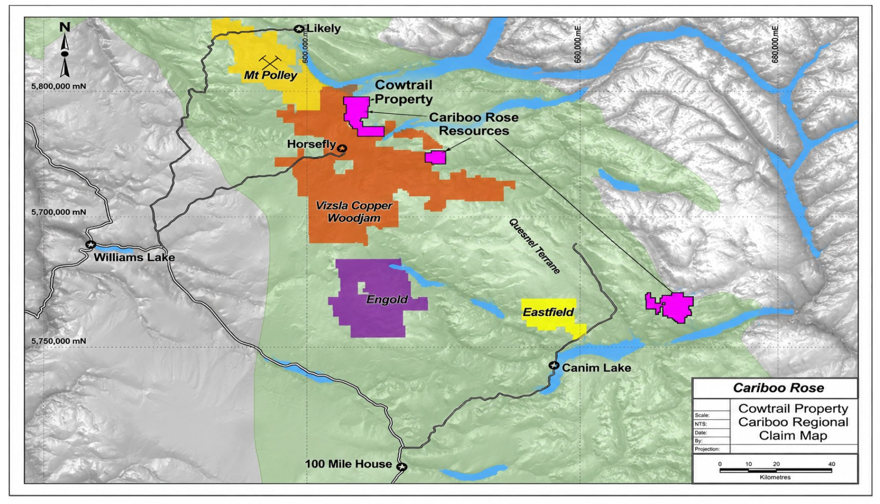
Regional location map showing the Cowtrail Property in south-central British Columbia, with Williams Lake, 100 Mile House, Mount Polley, Woodjam, Engold, Eastfield and the Quesnel Terrane shown for geographic context.
Cowtrail is under option to BRS Resources Ltd. who may earn a 60% interest by completing $2,000,000 in exploration expenditures, making $200,000 in cash payments, and issuing shares equivalent to $200,000 by December 19, 2028.
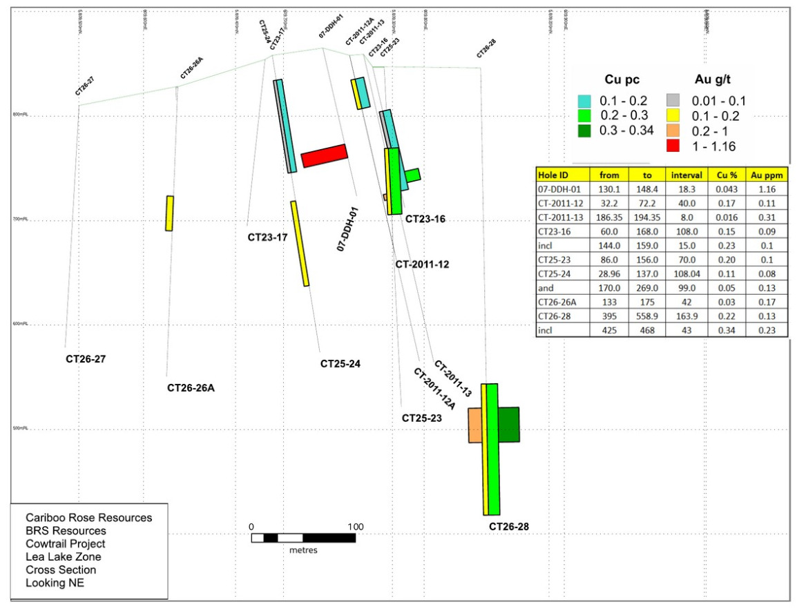
Figure-use note. The current drill density is insufficient to establish detailed geological relationships between holes. The plan view and section are included to show spatial relationships and reported assay intervals, particularly across the 2025 and 2026 drilling, without implying continuity beyond the available drilling.
Figure 1. Lake plan view showing drillhole locations, hole traces and reported copper and gold assay intervals
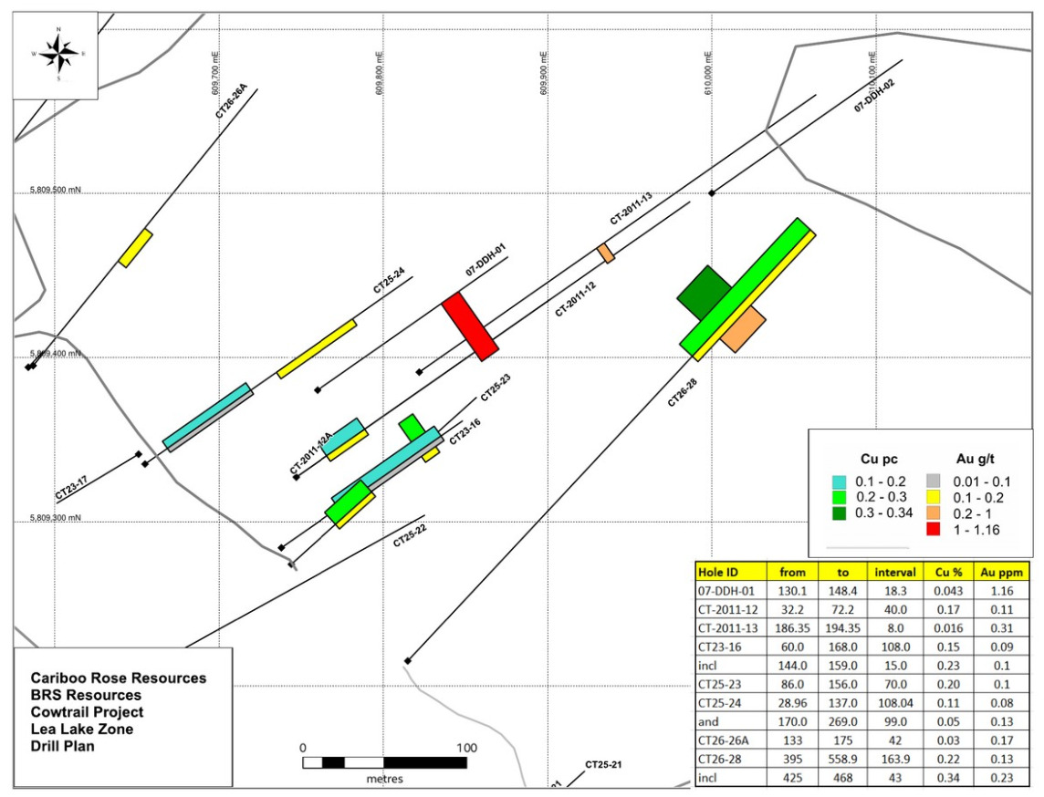
Figure 2. Lea Lake cross section looking northeast, showing drillhole traces and reported copper and gold assay intervals
J.W. (Bill) Morton, P.Geo., a Qualified Person under National Instrument 43-101, has reviewed and approved the technical content of this release.
Contact Information
Phone: (604) 681-7913
Toll Free: 888-656-6611
Website: www.cariboorose.com
Neither the TSX Venture Exchange nor its Regulation Services Provider accepts responsibility for the adequacy or accuracy of this release.